Devil's Bridge
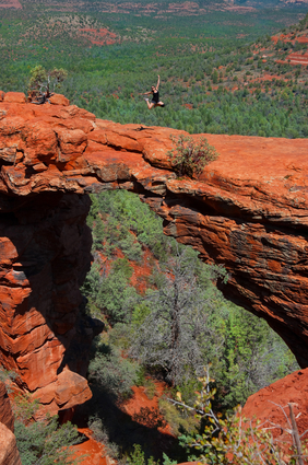
Hiker girl jumping in Devils bridge, Sedona Arizona
Though it's called a bridge, this next stop at the edge of Wide Valley on the north side of Capitol Butte is actually a red rock arch. This natural attraction is among the most viewed in the region, a geological wonder created by wind and weather erosion and not by flowing water, and an extremely heavily traveled arch at that! There is a small trailhead along Dry Creek Road that allows your group to take a minimum hike of 0.8 miles to get to the arch, however, you must have a four-wheel-drive vehicle to use that access road. If you don’t, you just follow the road down about another mile and hike it from there, adding a more scenic route for your group along the way.
Once here your group may also choose to take a recently created path called the Chuckwagon Trail, which links the road with the bridge trail at Long Chuckwagon Trailhead. The hike on any path you choose is fairly easy and mostly level, with a short steep climb at the end. The main path ends beneath the arch and ascents at the top, where the views up and down the canyon, over red and white rocks, and westwards across Wider Dry Creek Valley to the mesas of the red rock wildlife area, are absolutely unbeatable! Bring your best hiking shoes, bottles of water, and a camera with plenty of storage so you can take it all in and not miss a moment of this gorgeous red rock arch known as Devil’s Bridge!